 |
 |
 |
| Superintendent | Senator (senior) | Senator (junior) |
| Miatta Dorley | Edwine Snowe | Alex Jenekai Tyler Sr. |
All Districts Leadership in Bomi
|
|
|
| Superintendent | Senator (senior) | Senator (junior) |
| Name | Name | Name |
| County Profile Overview | |||||
|---|---|---|---|---|---|
| Year Established | Capital | Population (2022) | Area | Electoral Districts | Population Density |
| 1984 | Tubmanburg | 133,705 | 1,942 km² | 3 | 68.9 persons/km² |
Created in 1984, Bomi County, located in Liberia, is a first-level administrative division with its capital in Tubmanburg.
Background and Introduction
Spanning 1,942 square kilometers (km²), Bomi is one of Liberia’s 15 counties situated in the Northwestern region of Liberia and bordered by barpolu County in the North, Grand Cape Mount County in the West, Montserrado County in the East and the Atlantic Ocean in the South.
Bomi County is administratively divided into several districts for local governance and development administration.
There are 3 Electoral Districts (ED) 1, 2 and 3; and 5 Administrative Districts (AD) (Dowein, Klay, Suehn Mecca, Senjeh and Tehr), comprising 5 Chiefdoms and 18 Clans. County leadership is headed by a superintendent, while districts, townships, and boroughs are governed by representatives and senators, commissioners, and governors respectively. See the table below:
| Administrative Structure Overview: Bomi | ||
|---|---|---|
| Category | Count | Details |
| Electoral Districts | 3 | ED 1, ED 2, ED 3 |
| Administrative Districts | 5 | Dowein, Klay, Suehn Mecca, Senjeh, Tehr |
| Chiefdoms | 5 | County total |
| Clans | 18 | County total |
According to the 2022 census by the Liberia Institute of Statistics and Geo-Information Services (LISGIS), the population of the administrative districts stands at 133,705 made up of 68,574 males and 65,131 females representing 51.3% and 48.7% respectively. See the table below:
| Administrative Districts Population Overview: Bomi (County Total: 133,705) | ||||||
|---|---|---|---|---|---|---|
| Admin District | Male | Male % | Female | Female % | Total | % of County Population |
| Klay | 13,238 | 51.5% | 12,482 | 48.5% | 25,720 | 19.2% |
| Suehn Mecca | 8,577 | 52.9% | 7,642 | 47.1% | 16,219 | 12.1% |
| Senjeh | 26,905 | 51.0% | 25,835 | 49.0% | 52,740 | 39.4% |
| Dowein | 14,495 | 51.1% | 13,876 | 48.9% | 28,371 | 21.2% |
| Tehr | 5,359 | 50.3% | 5,296 | 49.7% | 10,655 | 8.0% |
| Total | 68,574 | 51.3% | 65,131 | 48.7% | 133,705 | 100.0% |
According to the 2022 census by the Liberia Institute of Statistics and Geo-Information Services (LISGIS), the population stands at 133,705 (68,574 males and 65,131 females) representing 51.3% and 48.7% respectively and 2.55% of the national population figure of 5,250,187. See the table below:
| County Population Overview: Bomi | ||||||
|---|---|---|---|---|---|---|
| Population (2022) | Male | Percent | Female | Percent | National Percentage | National Total |
| 133,705 | 68,574 | 51.3% | 65,131 | 48.7% | 2.5% | 5,250,187 |
Bomi County is a predominately Gola-speaking region, though there are at least 15 different dialects or languages spoken. The population is predominantly made up of four ethnic groups, namely Gola, Dei, Mandingo and Kpelle, though all of Liberia’s 16 major groups are thought to be represented. Some 70% of the active workforce is engaged in agriculture.
The proximity of Bomi to Montserrado County rendered it vulnerable during the war as the various fighting groups struggled at various times to take control of the capital. In the war years, the fighters committed serious atrocities against the people and lay waste to private property and public infrastructure. Nevertheless, Bomi County is well-situated to recover strongly from the war, being endowed with ample natural resources such as rubber, timber, diamonds, iron ore, gold, water, stone and sand, and fertile agricultural land.
History
Bomi County, formerly known as Bomi Territory, was annexed from Montserrado County by decree during the military regime of Samuel Doe in 1983 and later recognized by an act of legislation.Bomi means “light” in the Gola language, symbolizing the County’s uniqueness as the first cradle for iron ore mining in Liberia. Before the national crisis, iron ore mining flourished in Bomi County, starting in the 1950s. Rubber has also long been an important export from Bomi, and the second largest rubber plantation in Liberia, the Guthrie plantation, is situated here.
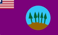
Flag
The flag of Bomi County represents the county’s mineral resources, forests, and agricultural landscape. It incorporates a miniature Liberian national flag in the canton and the county emblem placed on the field to symbolize Bomi’s identity within the Republic.
Technical Description
The flag features a rich, fertile land crisscrossed with rolling hills, with trees in the background. In the upper hoist corner appears a small depiction of the national flag of Liberia. The county emblem appears on the field representing natural resources and mining heritage.
Design Elements and Symbolism
Hills and Tress – Represent the rich iron ore, while the trees depict the fertility of the soil.
Liberian Flag Canton – Represents unity with the Republic of Liberia.
County Emblem – Includes symbols of mining, agriculture, and natural landscape.
Climate
Bomi County is generally warm throughout the year. It has two seasons: the rainy season beginning in April and ending in October, and the dry season covering the months of November to March. The average annual rainfall of Bomi County is approximately 80 inches.
Topography
Bomi County is generally hilly with a few plains and valleys. The County is endowed with ample water resources to supply fish and other livelihood options, including the Atlantic Ocean and the Po, Wlein, Mahei, Lofa, and St. Paul Rivers, among others. Many of the rivers are suitable for mini hydroelectric generation to supply electricity to citizens and industry.
Geology
In general, Bomi County has a sandy clay soil type.
Vegetation
There are many valuable commercial timber species found in the County. However, currently there exists no large-scale logging activity. Timber processing and pit sawing are carried out only at a small scale. Bomi County is a fertile land with rolling hills. Approximately, 45% of the land is covered by grassland.
Credit Sources:
Republic of Liberia – Ministry of Internal Affairs
Liberian Government Gazette (1964 Establishment Act)
National Archives of Liberia
Bomi County Administration
Official County Publications
County Development Agenda (CDA)
2022 Housing and Population Census: Liberia Institute of Statistics and Geo-Information Services (LISGIS)
National Elections Commission (NEC), Republic of Liberia
Senate.gov.lr
Bomi District 1
Bomi Electoral District 1 has a registered voter population of 19,236 made up of 9,817 males and 9,419 females as of July 2023. See the Table below.
Bomi District 2
Bomi Electoral District 2 has a registered voter population of 19,143 made up of 9,722 males and 9,421 females as of July 2023. See the Table below.
Bomi District 3
Bomi Electoral District 3 has a registered voter population of 24,733 made up of 12,889 males and 11,844 females as of July 2023. Below is the Table.
Bomi Districts (Administrative)
Bomi County has 5 administrative districts being Dowein, Klay, Suehn Mecca, Senjeh and Tehr with a population of 133,705.