 |
 |
 |
| Superintendent | Senator (senior) | Senator (junior) |
| Ojay Godfavor Morris | Emmanuel J. Nuquay | Nathaniel F. McGill |
| County Profile Overview: Margibi | |||||
|---|---|---|---|---|---|
| Year Established | Capital | Population (2022) | Area | Electoral Districts | Population Density |
| 1985 | Kakata | 304,946 | 2,615km² | 5 | 116.61 persons/km² |
Created in 1985, Margibi County, located in Liberia, is a first-level administrative division with its capital Kakata.
Background and Introduction
Spanning 2,615 square kilometers (km²), Grand Bassa is one of Liberia’s 15 counties situated in the western region of Liberia and
2,866.67 square miles, Margibi is one of Liberia’s 15 counties situated along the Atlantic Ocean in the South and neighbors Montserrado County on the East, Bong County on the North and Northeast, and Grand Bassa County on the West.
There are 5 Electoral Districts (ED) 1, 2, 3, 4, and 5; and 6 Administrative Districts (Farmington, Gibi, Kakata, Mambahn Kabah, Kabah Administrative, and Gounwolaila), comprising 4 Chiefdom and 17 Clans. County leadership is headed by a superintendent, while districts, townships, and boroughs are governed by representatives and senators, commissioners, and governors respectively. See the Table below.
| Administrative Structure Overview: Margibi | ||
|---|---|---|
| Category | Count | Details |
| Electoral Districts | 5 | ED 1, ED 2, ED 3, ED 4, ED 5 |
| Administrative Districts | 6 | Farmington, Gibi, Kakata, Mambahn Kabah, Kabah Administrative, Gounwolaila |
| Chiefdoms | 4 | County total |
| Clans | 17 | County total |
According to the 2022 census by the Liberia Institute of Statistics and Geo-Information Services (LISGIS), the population stands at 304,946 made up of 152,699 males and 152,247 females representing 50.1% and 49.9.% respectively. See the Table below.
| Administrative Districts Population Overview: Margibi (County Total: 304,946) | ||||||
|---|---|---|---|---|---|---|
| Admin District | Male | Male % | Female | Female % | Total | % of County Population |
| Farmington | 27,507 | 50.7% | 26,750 | 49.3% | 54,257 | 17.8% |
| Gibi | 7,837 | 50.9% | 7,543 | 49.1% | 15,380 | 5.0% |
| Kakata | 61,873 | 50.0% | 61,967 | 50.0% | 123,840 | 40.6% |
| Mambah Kaba | 18,903 | 50.0% | 18,884 | 50.0% | 37,787 | 12.4% |
| Kabah Administrative | 36,579 | 49.6% | 37,103 | 50.4% | 73,682 | 24.2% |
| Gounwolaila | 9,513 | 52.9% | 8,473 | 47.1% | 17,986 | 5.9% |
| Total | 152,699 | 50.1% | 152,247 | 49.9% | 304,946 | 100.0% |
According to the 2022 census by the Liberia Institute of Statistics and Geo-Information Services (LISGIS), the population stands at 304,946 made up of 152,699 males and 152,247 females representing 50.1% and 49.9.% respectively and 5.81% of the national population figure of 5,250,187. See the Table below.
| County Population Overview: Margibi | ||||||
|---|---|---|---|---|---|---|
| Population (2022) | Male | Percent | Female | Percent | National Percentage | National Total |
| 304,946 | 152,699 | 50.1% | 152,247 | 49.9% | 5.81% | 5,250,187 |
The County was established by an act of the Interim National Assembly (INA), a body that succeeded the People’s Redemption Council (PRC), which had come to power through a bloody military coup. In the middle of the flag are a rubber tree and a rubber tapper, which is an indication of the abundant rubber farms and plantations found across the County, which provide employment for thousands..
Ten major dialects are spoken in the County include Bassa (spoken by the majority 48%), Kpelle (spoken by 44%), Kissi (Spoken by 2%), Gbandi (Spoken by 1%), Gio (Spoken by 1%), Gola (Spoken by 1%), Grebo (Spoken by 1%), Lorma (Spoken by 1%), Mano (Spoken by 1%), and Vai (Spoken by 1%) and Others.
History
Margibi County is located in central Liberia just about 45 minutes’ drive from Monrovia. It is one of the newest counties, created just prior to the civil war. It was founded in 1984 as the 13th county, when two territories, Marshall and Gibi, were removed from Montserrado County and merged to form Margibi. The name derives from “Mar” for Marshall Territory and “Gibi” from Gibi District.”
Several important events occurred between 1975 and 1985, including a rash of severe storms in Firestone that caused mass destruction of lives and property, the construction of the Borlola River Bridge, the construction of the Totota to Ganta Highway by the Pototore Construction Company, the commencement of operations of the Ex-Chem Company in Charlesville Township, the construction of the Marshall Health Center by the Government of Liberia, and the granting of city status to Kakata.
The period from 1985 to 1995 also witnessed key developments, paramount among them being the construction of the Nyafor Bridge linking Margibi to Bong County, and the construction of the Harbel Multilateral High School. ”
The early 1990’s witnessed the beginning of the civil war. The period 1996 to 2006 was marked by a transition from war to recovery. Major events included the establishment of GSM communication facilities, the establishment of several community radio stations including Radio Kakata (in Kakata Upper Margibi) and Radio Peace (in Harbel Lower Margibi), the construction of a clinic and junior High School in Zewoh Mambah District, the Ellen Johnson Sirleaf Public School in Zuawien, and the construction of the Bueleqlleh Public School in Cinta. Recent years have seen the building of a resource center for women and the contribution of two lots of land to the disabled community by the County Administration.
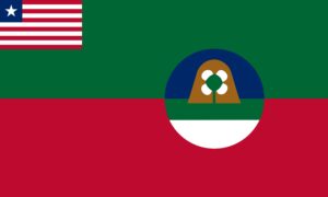
Flag
The flag of Margibi represents natural vegetation and agriculture and struggle towards the freedom of the county.
Technical Description
The flag features a background of two major colours, green and red. In the middle of the flag are a rubber tree and a rubber tapper with the Liberian flag in the canton and the county seal displayed on the field.
flag is comprised of two major colors, green and red. The green color represents the forest region of the County and its abundant natural vegetation. The red represents the county’s share of the struggle that brought in the military and subsequently transformed the country from Military to Civilian rule. In the middle of the flag are a rubber tree and a rubber tapper, which is an indication of the abundant rubber farms and plantations found across the County, which provide employment for thousands
Design Elements and Symbolism
Green Rubber Tree – Rubber tree and a rubber tapper, which is an indication of the abundant natural vegetation rubber farms and plantations found across the County, which provide employment for thousands.
Red – Represents the county’s share of the struggle that brought in the military and subsequently transformed the country from Military to Civilian rule.
Liberian Flag Canton – National unity.
Climate
The climate in Margibi County is tropical, hot and humid. Based on the prevailing precipitation, two seasons are differentiated. The rainy season lasts from mid April to mid-October. The dry season begins in November and ends in April. The temperature normally ranges annually from 24C to 30C (75F to 85F). Data on winds in Margibi County is incomplete, but wind generally blows from the Northeast during the dry season and from the Southwest during the rainy season. The total wind mileage is greatest in the rainy season from July to September and lowest in the dry season during December and January.
Margibi County has an average rainfall of around 115 inches (2,900mm). Three principal types of rainfall can be distinguished. First, heavy downpours occur at the beginning and at the end of the rainy season. Second, longer periods of precipitation with less turbulence occur, covering larger areas. The intensity of this kind of rainfall is increased through the drop of temperature during the afternoon and the night hours.
Third, “Relief Rains” are produced by the friction between the topography and air masses which reach the county from the sea. Relief rains occur at mountain ranges and other relief features.
Topography
A narrow coastal plain extends inland from the coastline, and the land gradually rises to the high Bong Range in the Northwest, and Gibi Mountain in the North, bordering Grand Bassa County. Margibi County’s most important rivers are the Farmington, which forms the border with Grand Bassa County, and the Du River, which forms the border with Montserrado County. Both rivers have the potential for hydroelectric power generation.
Geology
The soil is excellent for agricultural production and many cash crops. The soil in the Lower part is mostly sandy clay loam, with an abundance.
Vegetation
High-elevation regions have forests of evergreen and deciduous trees, including ironwood and mahogany. Mangrove swamps are found mainly in the coastal areas.
Religion and Culture
About 90% of the County’s population is Christian, with roughly 5% Muslims and 5% Animists.
Ethnic Composition
The Bassa is the dominant ethnic group, though all or nearly all of Liberia’s tribes are represented in the County. Below is a table showing the percentage distribution of dialects spoken in Margibi County
Ten major dialects are spoken in the County. These include Bassa (spoken by the majority 48%), Kpelle (spoken by 44%), Kissi (Spoken by 2%), Gbandi (Spoken by 1%), Gio (Spoken by 1%), Gola (Spoken by 1%), Grebo (Spoken by 1%), Lorma (Spoken by 1%), Mano (Spoken by 1%), and Vai (Spoken by 1%) and Others.
Credit Sources:
Republic of Liberia – Ministry of Internal Affairs
Liberian Government Gazette (1964 Establishment Act)
National Archives of Liberia
Margibi County Administration
Official County Publications
County Development Agenda (CDA)
2022 Housing and Population Census: Liberia Institute of Statistics and Geo-Information Services (LISGIS)
National Elections Commission (NEC), Republic of Liberia
Senate.gov.lr
Margibi District 1
Margibi Electoral District 1 has a registered voter population of 62,849 made up of 30,821 males and 32,028 females as of July 2023. See the Table below. District Population Overview: Margibi Electoral District 1 Population (2023) Male Percent Female Percent 62,849 30,821 49.04% 32,028 50.96%
Margibi District 2
Margibi Electoral District 2 has a registered voter population of 33,434 made up of 16,855 males and 16,579 females as of July 2023. See the Table below. District Population Overview: Margibi Electoral District 2 Population (2023) Male Percent Female Percent 33,434 16,855 50.41% 16,579 49.59%
Margibi District 3
Margibi Electoral District 3 has a registered voter population of 30,547 made up of 14,294 males and 16,253 females as of July 2023. See the Table below. District Population Overview: Margibi Electoral District 3 Population (2023) Male Percent Female Percent 30,547 14,294 46.80% 16,253 53.20%
Margibi District 4
Margibi Electoral District 4 has a registered voter population of 28,510 made up of 14,542 males and 13,968 females as of July 2023. Sere the Table below. District Population Overview: Margibi Electoral District 4 Population (2023) Male Percent Female Percent 28,510 14,542 51.01% 13,968 48.99%
Margibi District 5
Margibi Electoral District 5 has a registered voter population of 29,961 made up of 15,111 males and 14,850 females as of July 2023. See the Table below. District Population Overview: Margibi Electoral District 5 Population (2023) Male Percent Female Percent 29,961 15,111 50.44% 14,850 49.56%
Margibi Districts (Administrative)
Margibi County has 6 Administrative (Farmington, Gibi, Kakata, Mambahn Kabah, Kabah Administrative, and Gounwolaila), with a population of 304,946.