 |
 |
|
| Superintendent | Senator (senior) | Senator (junior) |
| Karyou Johnson | Nyonblee Karnga-Lawrence | Gbehzohngar Milton Findley |
All Districts Leadership in Grand Bassa
| County Profile Overview: Grand Bassa | |||||
|---|---|---|---|---|---|
| Year Established | Capital | Population (2022) | Area | Electoral Districts | Population Density |
| 1833 | Bopolu | 293,689 | 7,932 km² | 7 | 37.03 persons/km² |
Created in 1833, Grand Bassa County, located in Liberia, is a first-level administrative division with its capital is Buchanan.
Background and Introduction
Spanning 7,932 square kilometers (km²), Grand Bassa is one of Liberia’s 15 counties situated in the western region of Liberia and bordered by Margibi on the Northwest, Bong on the North, Nimba on the East, and River Cess on the Southeast.
There are 5 Electoral Districts (ED) 1, 2, 3, 4 and 5; and 7 Administrative Districts (District 1 (Dianblae), District 2 (Glarkon), St. John River City, Neekreen, Commonwealth, District Number 3 (Wee), and District Number 4 (Kpaoegbarn), comprising 18 Chiefdoms and 45 Clans. County leadership is headed by a superintendent, while districts, townships, and boroughs are governed by representatives and senators, commissioners, and governors respectively. See the Table below.
| Administrative Structure Overview: Grand Bassa | ||
|---|---|---|
| Category | Count | Details |
| Electoral Districts | 5 | ED 1, ED 2, ED 3, ED 4, ED 5 |
| Administrative Districts | 7 | District 1 (Dianblae), District 2 (Glarkon), St. John River City, Neekreen, Commonwealth, District Number 3 (Wee), District Number 4 (Kpaoegbarn) |
| Chiefdoms | 18 | County total |
| Clans | 45 | County total |
According to the 2022 census by the Liberia Institute of Statistics and Geo-Information Services (LISGIS), the population stands at 293,689 made up of 150,280 males and 143,409 females representing 51.1% and 48.9.% respectively. See the Table below.
| Administrative Districts Population Overview: Grand Bassa (County Total: 293,689) | ||||||
|---|---|---|---|---|---|---|
| Admin District | Male | Male % | Female | Female % | Total | % of County Population |
| District 1 (Dianblae) | 16,003 | 52.9% | 14,220 | 47.1% | 30,223 | 10.3% |
| District 2 (Glarkon) | 16,957 | 52.1% | 15,608 | 47.9% | 32,565 | 11.1% |
| St. John River City | 7,446 | 52.2% | 6,827 | 47.8% | 4,273 | 1.5% |
| Neekreen | 31,193 | 49.6% | 31,690 | 50.4% | 62,883 | 21.4% |
| Commonwealth | 17,719 | 49.6% | 18,021 | 50.4% | 35,740 | 12.2% |
| District 3 (Wee) | 31,965 | 51.2% | 30,456 | 48.8% | 62,421 | 21.3% |
| District 4 (Kpaoegbarn) | 21,606 | 52.5% | 19,556 | 47.5% | 1,162 | 0.4% |
| Total | 150,280 | 51.1% | 143,409 | 48.9% | 293,689 | 100.0% |
According to the 2022 census by the Liberia Institute of Statistics and Geo-Information Services (LISGIS), the population stands at 293,689 made up of 150,280 males and 143,409 females representing 51.2% and 48.8.% respectively and 5.59% of the national population figure of 5,250,187. See the Table below.
| County Population Overview: Grand Bassa | ||||||
|---|---|---|---|---|---|---|
| Population (2022) | Male | Percent | Female | Percent | National Percentage | National Total |
| 293,689 | 150,280 | 51.2% | 143,409 | 48.8% | 5.59% | 5,250,187 |
Bassa-speaking people are in the majority, making up 94% of the County’s population. Other ethnic groups in the County include the Kpelle (5%), and the Kissi (1%), and small numbers of other groups. The Kru, often originating from neighboring Sinoe County, and Fanti fishermen and traders are also a part of the population.
History
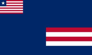
Grand Bassa County is one of the three original counties, along with Montserrado and Sinoe, that first formed the Republic of Liberia. It was established in 1833 and its capital is Buchanan City, named for Thomas Buchanan, an American who served as the first Governor of the Commonwealth of Liberia. The County’s flag is a royal blue cloth with the Liberian flag inserted in the upper left corner and two red and two white stripes in the lower right. The dark blue stands for loyalty, while the stripes represent the four Grand Bassa delegates who signed Liberia’s Declaration of Independence on 26 July 1847, namely Anthony Gardner, John Day, Ephraim Titler, and Amos Herring.
The County went through a series of political and territorial metamorphoses over the years until, on 18 April 1985, during the administration of Samuel Doe, the part of the County known as River Cess was promoted to status as a County, thus splitting the region away from Grand Bassa.
In October 2003, a few days before the end of the mandate of the 51st national Legislature, the County’s previous four districts (District #1, #2, #3, and #4) were divided into its current five statutory districts, nine administrative districts, eleven townships, three cities (Buchanan, Edina, and St. John River City) and forty-five clans. This most recent restructuring has resulted in confusion for many citizens, who still tend to use the names of the previous denominations. Many organizations continue to organize their activities and collect data according to the old structure, contributing to the confusion.
Flag
The flag of Grand Bassa consists symbolizes maritime heritage and coastal trade.
Technical Description
The flag features a dark blue background and two red and two white stripes. A small Liberian flag appears in the canton. The county seal appears on the field.
Design Elements and Symbolism
Dark Blue Field – Represents loyalty.
Red and White Stripes – Two red and two white stripes represents the four Grand Bassa delegates who signed Liberia’s Declaration of Independence on 26 July 1847, namely Anthony Gardner, John Day, Ephraim Titler, and Amos Herringity.
Liberian Flag Canton – National unity.
County Seal – Represents coastal trade and agriculture.
Climate
The climate is tropical, hot and humid; Bassa is among the wettest counties of Liberia with an annual average rainfall of about 400 mm per year. Based on the prevailing precipitation, two seasons are differentiated – rainy and dry. The rainy season lasts from late April to October. The dry season begins in November and ends in April.
Topography
Grand Bassa has a flat coastline. A narrow coastal plain extends inland from the seashore, and the land gradually rises to the hilly hinterland of the County. High elevation regions have forest of evergreen and deciduous trees, including ironwood and mahogany.
The County has several major rivers. These are St. John, Farmingtohn, Merchin, New Cess, Ilor, Timbo, and Benson River. Consequently, the shore is broken by estuaries, tidal creeks, and rocky capes. The coastal region does not rise more than 60 to 70 meters, excepting occasional small hills. This situation makes several settlements near the sea—including Buchanan City—vulnerable to inundation and erosion.
Moreover, Benson River and Merclin River overflow the banks in some areas during the rainy season. As a result, many villages remain inaccessible during certain periods of the year due to the deteriorated roads.
Geology
The County’s soils can be categorized as laterite (55%), which is leached out, alluvial (19%) and sandy and loamy (26%). Alluvial soil is prevalent in the leeward districts. Two onshore sediment-filled basins are located along the coastline: Roberts Basin, which is filled with sediments of the Farmington River formation and Paynesville sandstone; and the Bassa Basin, which is filled with material from the St. John River formation.
Vegetation
Grand Bassa is generally covered by green forest, but there is also savanna. The territory not covered by the forest is used for farming using traditional methods. Rubber trees and palms are also planted in the concession areas and on small private farms.
Credit Sources:
Republic of Liberia – Ministry of Internal Affairs
Liberian Government Gazette (1964 Establishment Act)
National Archives of Liberia
Grand Bassa County Administration
Official County Publications
County Development Agenda (CDA)
2022 Housing and Population Census: Liberia Institute of Statistics and Geo-Information Services (LISGIS)
National Elections Commission (NEC), Republic of Liberia
Senate.gov.lr
Grand Bassa District 1
Grand Bassa Electoral District 1 has a registered voter population of 27,962 made up of 14,414 males and 13,548 females as of July 2023. See the Table below. District Population Overview: Grand Bassa Electoral District 1 Population (2023) Male Percent Female Percent 27,962 14,414 51.55% 13,548 48.45%
Grand Bassa District 2
Grand Bassa Electoral District 2 has a registered voter population of 30,726 made up of 15,317 males and 15,409 females as of July 2023. See the Table below. District Population Overview: Grand Bassa Electoral District 2 Population (2023) Male Percent Female Percent 30,726 15,317 49.85% 15,409 50.15%
Grand Bassa District 3
Grand Bassa Electoral District 3 has a registered voter population of 38,527 made up of 18,430 males and 20,097 females as of July 2023. See the Table below. District Population Overview: Grand Bassa Electoral District 3 Population (2023) Male Percent Female Percent 38,527 18,430 47.84% 20,097 52.16%
Grand Bassa District 4
Grand Bassa Electoral District 4 has a registered voter population of 30,749 made up of 15,405 males and 15,344 females as of July 2023. See the Table below. District Population Overview: Grand Bassa Electoral District 4 Population (2023) Male Percent Female Percent 30,749 15,405 50.10% 15,344 49.90%
Grand Bassa District 5
Grand Bassa Electoral District 5 has a registered voter population of 30,499 made up of 15,656 males and 14,843 females as of July 2023. See the Table below. District Population Overview: Grand Bassa Electoral District 5 Population (2023) Male Percent Female Percent 30,499 15,656 51.33% 14,843 48.67%
Grand Bassa Districts (Administrative)
Grand Bassa County has 7 Administrative (District 1 (Dianblae), District 2 (Glarkon), St. John River City, Neekreen, Commonwealth, District Number 3 (Wee), and District Number 4 (Kpaoegbarn), with a population of 293,689.