 |
 |
 |
| Superintendent | Senator (senior) | Senator (junior) |
| Ma Kou Meapeh Gono | Prince Johnson | Nya D. Twayen Jr. |
All Districts Leadership in Nimba
| County Profile Overview: Nimba | |||||
|---|---|---|---|---|---|
| Year Established | Capital | Population (2022) | Area | Electoral Districts | Population Density |
| 1964 | Sanniquellie | 621,841 | 11,546km² | 9 | 53.86 persons/km² |
Created in 1964, Nimba County, located in Liberia, is a first-level administrative division with its capital Sanniquelle.
Background and Introduction
Spanning 11,546 square kilometers (km²), Nimba is situated in the Northeastern part of Liberia and shares borders with the Republic of Cote d’ Ivoire in the East, and the Republic of Guinea in the Northwest. Nimba is bordered by the counties of Bong, River Cess, Sinoe, and Nimba. Nimba has a distance of 298 kilometres from Monrovia to Sanniquellie.
There are 9 Electoral Districts (ED) 1, 2, 3, 4, 5, 6, 7, 8, and 9; and 17 Administrative Districts (Sanniquellie Mahn, Yarpea Mahn, Yarmein, Gbehlay-Geh, Twan River, Garr-Bain, Doe, Gbi & Doru, Kparblee, Boe & Quilla, Gbor, Zoe-Gbao, Yarwein Mehnsonnoh, Meinpea-Mahn, Leewehpea-Mahn, Wee-Gbehyi-Mahn, and Buu-Yao), comprising 34 Chiefdom and 72 Clans. County leadership is headed by a superintendent, while districts, townships, and boroughs are governed by representatives and senators, commissioners, and governors respectively.
According to the 2022 census by the Liberia Institute of Statistics and Geo-Information Services (LISGIS), the population stands at 621,841 made up of 312,018 males and 309,823 females representing 50.2% and 49.8.% respectively. See the Table below.
| Administrative Districts Population Overview: Nimba (County Total: 621,841) | ||||||
|---|---|---|---|---|---|---|
| Admin District | Male | Male % | Female | Female % | Total | % of County Population |
| Sanniquellie Mahn | 23,184 | 49.2% | 23,945 | 50.8% | 47,129 | 7.6% |
| Yarpea Mahn | 7,197 | 51.0% | 6,916 | 49.0% | 14,113 | 2.3% |
| Yarmein | 17,218 | 51.4% | 16,305 | 48.6% | 33,523 | 5.4% |
| Gbehlay-Geh | 25,323 | 50.2% | 25,127 | 49.8% | 50,450 | 8.1% |
| Twan River | 23,071 | 50.5% | 22,642 | 49.5% | 45,713 | 7.4% |
| Garr-Bain | 54,178 | 48.5% | 57,618 | 51.5% | 111,796 | 18.0% |
| Doe | 23,208 | 51.0% | 22,324 | 49.0% | 45,532 | 7.3% |
| Gbi & Doru | 4,297 | 52.9% | 3,821 | 47.1% | 8,118 | 1.3% |
| Kparblee | 8,601 | 50.7% | 8,357 | 49.3% | 16,958 | 2.7% |
| Boe & Quilla | 10,456 | 50.4% | 10,287 | 49.6% | 20,743 | 3.3% |
| Gbor | 5,382 | 50.4% | 5,298 | 49.6% | 10,680 | 1.7% |
| Zoe-Gbao | 19,099 | 49.8% | 19,257 | 50.2% | 38,356 | 6.2% |
| Yarwein Mehnsonnoh | 13,035 | 51.4% | 12,315 | 48.6% | 25,350 | 4.1% |
| Meinpea-Mahn | 15,069 | 51.4% | 14,244 | 48.6% | 29,313 | 4.7% |
| Leewehpea-Mahn | 13,862 | 50.9% | 13,345 | 49.1% | 27,207 | 4.4% |
| Wee-Gbehyi-Mahn | 22,451 | 49.9% | 22,577 | 50.1% | 45,028 | 7.2% |
| Buu-Yao | 26,387 | 50.9% | 25,445 | 49.1% | 51,832 | 8.3% |
| Total | 312,018 | 50.2% | 309,823 | 49.8% | 621,841 | 100.0% |
According to the 2022 census by the Liberia Institute of Statistics and Geo-Information Services (LISGIS), the population stands at 621,841 made up of 312,018 males and 309,823 females representing 50.2% and 49.8.% respectively and 11.84% of the national population figure of 5,250,187.
Nimba is the largest county by land size and the second most populous aside Montserrado. See the Table below.
| County Population Overview: Nimba | ||||||
|---|---|---|---|---|---|---|
| Population (2022) | Male | Percent | Female | Percent | National Percentage | National Total |
| 621,841 | 312,018 | 50.2% | 309,823 | 49.8% | 11.84% | 5,250,187 |
History
Nimba County is named after its tallest and largest mountain, Neinbaa Tohn. In Mano – one of the native languages of the County – the name means “a mountain on which sisters slip” or “a slipping mountain for sisters”. The County evolved from two provincial districts, Sanniquellie and Tappita, known as Districts II and III in the Central Province of Liberia until 1964. Prior to the extension of the Government of Liberia into the hinterland, the native Africans of present day Nimba, like other native African communities of the hinterland, practiced monarchy and were ruled by powerful kings and warriors in consultation with councils of elders in city states. This was until 1904, when President Arthur Barclay introduced Indirect Rule to govern the interior of the country, thus dividing the interior into Stations.
The Manos and Gios are the two principal ethnic groups of Nimba. They are believed to have been amongst the major migrations of 1450 to 1650 to what is today known as Liberia. Migrations during this period are said to have been induced by Arab invasions in northern Africa between the eighth and eleventh centuries and therefore the caution to avoid the dangers of increasing warfare. Also the development of agriculture stimulated the expansion toward the coast, particularly slash-and-burn techniques and rice cultivation (W.L. D’azevedo).
Nimba attained County status during the presidential tenure of William V. S. Tubman by an act of the National legislature in 1964. The first Superintendent of the County was Hon. Gabriel G. Farngalo. Sanniquellie was named as the capital. Sanniquellie played host to the first Africa state summit involving Guinea, Ghana and Liberia on 25th May 1959, chaired by Liberia’s William V. S. Tubman. This summit eventually led to the founding of the Organization of African Unity (now known as the African Union or AU) in Addis Ababa, May 1963.
Bordering Guinea and Cote D’ivore, that part of Liberia is of considerable geopolitical consequence.
The County bore the brunt of successive civil unrest since the 1980s. This is because some prominent sons of Nimba had been linked to coups and other forms of subversive activities in the County. It was from the border town of Buutuo that Charles Taylor launched his assault on the Doe’s regime on December of 1989, after a failed coup in 1985 led by General Thomas G. Quiwonkpa, a son of the County. It has been the site of repeated massacres and ethnic tensions.
Prior to the civil war, the Liberia-American Mining Company (LAMCO) was involved in iron ore mining in Yekepa. This company provided work, educational, medical care and other opportunities for both Liberians and non-Liberians in that part of the County. With the departure of the Americans, the company became a 100% Liberian company known as Liberian Mining Company (LIMICO). However, following the election of a democratic government after the war, a 25-year mining contract was signed between the Liberian government and ArcelorMittal in 2007. The company is expected to create over 3000 jobs initially.
Most of the basic social service infrastructure of the districts (schools, health facilities, power systems, water and sanitation, etc.) was destroyed during the civil war. This has contributed to the extreme vulnerability of the populations in terms of food security, health care and education. Limited employment opportunities in the districts were also lost. With the first post-war elected government and the assisted repatriation and resettlement of IDPs and refugees, communities are now beginning to rebuild their lives, but massive challenges remain.
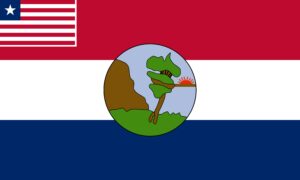
Flag
The flag of Nimba County represents mountainous terrain, mining resources, agriculture and the peaceful identity of its people.
Technical Description
The flag symbolized by a three-stripe colors, orange, white and blue. The basic features include mountainous elevation, a green field, a pickaxe and the sun with the Liberian flag in the canton and the county emblem on the field.
Design Elements and Symbolism
Orange Stripe – Rich mineral deposits of the county.
White Stripe – Represents peace.
Blue Stripe – Represents the sky.
Brown Mountain – Depicts the geographic landmark of Mount Nimba, the highest mountain of Liberia from which the county derived its name.
Sun – Represents harmony, and the diverse groups of people living in the county.
Pickaxe – Represents the mining of Iron ore industry, a key player in the economy of the county.
Green Field – Indicating the rich vegetation of the area
Climate
Nimba has a tropical climate. There are two seasons: wet and dry. According to the New Geography of Liberia, average rainfall in Nimba is recorded between 12.5 –25mm in January; between 100-150mm in the West and 150-200mm in the North, East and South of the County in April; and in October average rainfall is recorded between 200-250mm in the south-eastern portion and 250-300mm in the northwestern portion. Prevailing wind is generally south-easterly or monsoonal.
Geography
Nimba County is situated in the Northeastern part of Liberia and shares borders with the Republic of Cote d’ Ivoire in the East, and the Republic of Guinea in the Northwest. Nimba is bordered by the counties of Bong, River Cess, Sinoe, and Nimba. The total geographic area (of land and water) of Nimba is 2,300 square kilometres; from North to South, the County stretches 230 kilometres and East to West, 100 kilometres. It has a distance of 298 kilometres from Monrovia to Sanniquellie.
Topography
There are three principal topographic areas: the northern part of the County is dominated by mountains, hills and deep valleys. Prominent among the mountains is Mount Nimba. The highlands of Nimba form part of the Bleetro-Nimba Block in the Central Region of Liberia, one of three large mountain blocks of Liberia, the other two being the Kpo-Wologisi Block in the western region and the Tienpo-Putu Block in the Eastern region.
The Northern Highlands of Liberia are primarily found in Nimba and Lofa counties and form pa r t of t h e Gu i n e a Highlands also known as the Futa Jallon Mountains. Two relief features are characteristics of this re g i o n : l o n g r a n g e s a n d doomed-shaped hills. The Nimba Range rises north of Sanniquellie and after twenty miles extends into the Republic of Guinea, where it reaches an altitude of 6,083 feet.
The so-called ‘Guest House Hill” in the Yekepa area is the highest point of the Nimba Range on the Liberian side, and at the same time the highest elevation in Liberia, with an altitude of 4,540 feet above sea level. The south of the County is dominated by plains.
Nimba has four major rivers. St. John is the largest, forming the natural boundary between Liberia and Guinea in its upper stretch. It also internally separates Nimba and Bong counties. The Yah River also has its source from Mount Nimba and flows centrally through the County from north to south-west in a stretch of 200km. The Cestos River (also known as the Nooh River) has its source, too, in the Eastern part of Mount Nimba. The Cestos River constitutes the natural boundary between Liberia and Cote d’Ivore in the East. It has a stretch of over 300km and also borders Nimba with Grand Geddeh County. Other rivers in the County are the Twah River, Bee River and Weh River. Nimba County contains one artificial lake, Lake Teeleh in Sanniquellie City, which is 200m long and 120m wide.
Geology
The Soil types found in the County are reddish-brown soil and also range from gray to black soil. These soil types support the growth of a variety of tree crops such as rubber, oil palm, coffee, as well as corn and rice. In the southern part of the county, the soil type is sandy.
Vegetation
Nimba’s natural vegetation is composed of tropical rainforest, specifically high forest, broken forest and low bush. As in the other northern counties of Liberia the most prominent forest type is moist semi-deciduous. Trees of this forest type are the nesogordonia papaverifera, limba (terminalia superba), and obechi (triplochiton scleroxylon). Low bush establishes itself in the areas of land rotation where trees are cut and burnt as a result of the shifting or bush fallowing method of farming.
Typical trees of this vegetation type are the umbrella or corkwood tree (mussanga cecropioides) and the oil palm. Swamps are common in the County, and there is a small portion of the vegetation covered with scattered trees and dense elephant grass (pennisetum purpureum). There are, however no natural grass fields except those created by human activities through farming, habitation or the development of football fields.
The original vegetation of the County would have consisted of tropical rainforest, which was cut down primarily for farming purposes and the cultivation of other cash crops such as cocoa, coffee, oil palm and rubber. The land abandoned after farming is occupied by elephant grass that slows the regeneration of forest trees.
Religion and Culture
There are three major faiths practiced in Nimba: Christianity, Islam and the Bahai Faith. African traditional practices also have major impact on religious practices in the County. Christianity is the dominant religion, followed by Islam. The dominant local Christian denominations include the Catholic Church, Methodist Church, Baptist Church, Lutheran Church, Episcopal Church, Presbyterian Church, Pentecostal Related Churches, Seven Day Adventist, Jehovah Witnesses, Church of Christ, Mid-Baptist Church, Church of the Lord Aladura, and Inland Church.
Islam is practiced nearly in every district of the County. In addition to promoting their specific doctrines, religious institutions have served as partners to the Government and local communities in provide some basic services such as schools, health services, training, etc.
Ethnic Composition
All of Liberia’s sixteen (16) ethnic groups are found in Nimba, but five of the ethnic groups are represented in higher numbers: the Gio, Mano, Krahn, Gbi and Mandingo. Of the five, the Gio and Mano are the predominant ethnic groups and are members of the Mende Fu language group, one of four language groups in Liberia. Over the years, the tribal groups of the County have been interlinked through marriage.
The dialects spoken in the County include Mano (spoken by 35%), Gio (spoken by 30%), Sapo (spoken by 12%), Krahn (spoken by 10%), Gola (spoken by 5%), Bassa (spoken by 2%), Kpelle (spoken by 1%), Kru, Kissi, Gbandi, Grebo, Lorma, Vai (Spoken by 0%) and Others.
Credit Sources:
Republic of Liberia – Ministry of Internal Affairs
Liberian Government Gazette (1964 Establishment Act)
National Archives of Liberia
Nimba County Administration
Official County Publications
County Development Agenda (CDA)
2022 Housing and Population Census: LiberiaInstitute of Statistics and Geo-Information Services (LISGIS)
National Elections Commission (NEC), Republic of Liberia
Senate.gov.lr
Nimba District 1
Nimba Electoral District 1 has a registered voter population of 36,197 made up of 16,960 males and 19,237 females as of July 2023.
Nimba District 2
Nimba Electoral District 2 has a registered voter population of 38,662 made up of 18,659 males and 20,003 females as of July 2023.
Nimba District 3
Nimba Electoral District 3 has a registered voter population of 39,525 made up of 19,934 males and 19,591 females as of July 2023.
Nimba District 4
Nimba Electoral District 4 has a registered voter population of 35,350 made up of 17,522 males and 17,828 females as of July 2023.
Nimba District 5
Nimba Electoral District 5 has a registered voter population of 29,823 made up of 14,732 males and 15,091 females as of July 2023.
Nimba District 6
Nimba Electoral District 6 has a registered voter population of 29,994 made up of 14,993 males and 15,001 females as of July 2023.
Nimba District 7
Nimba Electoral District 7 has a registered voter population of 35,775 made up of 18,045 males and 17,730 females as of July 2023.
Nimba District 8
Nimba Electoral District 8 has a registered voter population of 34,283 made up of 16,931 males and 17,352 females as of July 2023.
Nimba District 9
Nimba Electoral District 9 has a registered voter population of 27,645 made up of 14,141 males and 13,504 females as of July 2023.