 |
 |
 |
| Superintendent | Senator (senior) | Senator (junior) |
| Henry B Cole Jr. | J. Gbleh-bo Brown | James P. Biney |
All Districts Leadership in Maryland
| County Profile Overview: Maryland | |||||
|---|---|---|---|---|---|
| Year Established | Capital | Population (2022) | Area | Electoral Districts | Population Density |
| 1857 | Harper | 172,587 | 2,296km² | 3 | 75.17 persons/km² |
Created in 1857, Maryland County, located in Liberia, is a first-level administrative division with its capital Harper.
Background and Introduction
Spanning 2,296 square kilometers (km²), Maryland is located in the Southeast most corner of Liberia and borders the Atlantic ocean to the South; the Cavalla River representing the international border with the Republic of Ivory Coast to the East; Grand Kru County on the West; and River Gee County to the Northwest.
There are 3 Electoral Districts (ED) 1, 2, and 3; and 7 Administrative Districts (Harper, Pleebo/Sodoken, Karluway #1, Karluway #2, Whojah, Nyonken and Gwelekpoken), comprising 15 Chiefdom and 33 Clans. County leadership is headed by a superintendent, while districts, townships, and boroughs are governed by representatives and senators, commissioners, and governors respectively. See the Table below.
| Administrative Structure Overview: Maryland | ||
|---|---|---|
| Category | Count | Details |
| Electoral Districts | 3 | ED 1, ED 2, ED 3 |
| Administrative Districts | 7 | Harper, Pleebo/Sodoken, Karluway #1, Karluway #2, Whojah, Nyonken, Gwelekpoken |
| Chiefdoms | 15 | County total |
| Clans | 33 | County total |
According to the 2022 census by the Liberia Institute of Statistics and Geo-Information Services (LISGIS), the population stands at 172,587 made up of 86,867 males and 85,720 females representing 50.3% and 49.7.% respectively. See the Table below.
| Administrative Districts Population Overview: Maryland (County Total: 172,587) | ||||||
|---|---|---|---|---|---|---|
| Admin District | Male | Male % | Female | Female % | Total | % of County Population |
| Whoja | 2,365 | 53.5% | 2,059 | 46.5% | 4,424 | 2.6% |
| Gwelekpoken | 2,296 | 52.6% | 2,070 | 47.4% | 4,366 | 2.5% |
| Nyorken | 3,375 | 50.7% | 3,283 | 49.3% | 6,658 | 3.9% |
| Karluway Number 1 | 3,845 | 52.0% | 3,546 | 48.0% | 7,391 | 4.3% |
| Karluway Number 2 | 5,985 | 52.6% | 5,385 | 47.4% | 11,370 | 6.6% |
| Pleebo/ Sodoken | 42,249 | 49.5% | 43,038 | 50.5% | 85,287 | 49.4% |
| Harper | 26,752 | 50.4% | 26,339 | 49.6% | 53,091 | 30.8% |
| Total | 86,867 | 50.3% | 85,720 | 49.7% | 172,587 | 100.0% |
According to the 2022 census by the Liberia Institute of Statistics and Geo-Information Services (LISGIS), the population stands at 172,587 made up of 86,867 males and 85,720 females representing 50.3% and 49.7.% respectively and 3.29% of the national population figure of 5,250,187. See the Table below.
| County Population Overview: Maryland | ||||||
|---|---|---|---|---|---|---|
| Population (2022) | Male | Percent | Female | Percent | National Percentage | National Total |
| 172,587 | 86,867 | 50.3% | 85,720 | 49.7% | 3.29% | 5,250,187 |
The dialects spoken in the County include Grebo (spoken by the majority 99%), Kru (spoken by 1%), Bassa, Kissi, Gbandi, Gio, Gola, Grebo, Lorma, Mano, Kpelle, Krahn, Sapo (Spoken by 0%) and Others.
History
Maryland County is one of the first four counties of the Republic of Liberia. Initially this County was not part of the Republic of Liberia during its founding. The County was established by a resolution of the Legislature of the Republic of Liberia in 1857. The resolution admitted the State of Maryland in Liberia as a County to the Republic with all privileges, immunities and rights accorded the three original counties. The Maryland State Colonization Society as a home land founded the territory on 12 February 1834 for free American Slaves. The territory was first established as the Colony of Maryland. It was incorporated into the “Republic of Liberia in 1857. Harper City is the political capital of the County and is also known as “Cape Palmas”.
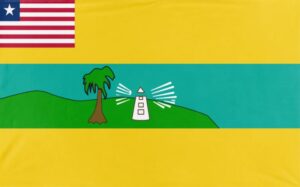
The flag of Maryland County has three major colors, green, blue and yellow, with a palm tree and lighthouse inscribed in the field. The green color and the palm tree denote the county’s abundant natural vegetation; the yellow colour depicts the “sunshine”, the blue colour for the ‘valour’ of the County and the lighthouse as a guide for navigation. The County flag also has an insertion of the Liberian National Flag on the upper left-side.
Flag
The flag of Maryland represents maritime heritage and coastal trade.
Technical Description
The flag has three major colors, green, blue and yellow, with a palm tree and lighthouse inscribed in the field and incorporates coastal imagery with a small Liberian flag in the canton and the county emblem on the field.
Design Elements and Symbolism
Green Palm Tree – Denote the county’s abundant natural vegetation.
Maritime imagery (Lighthouse) – Guide for navigation, fishing and trade.
Yellow – Represents sunshine.
Blue – Represents the ‘valour’ of the County.
Liberian Flag Canton – National unity.
Climate
Maryland County is situated in the 100 to 120 inches rainfall zone. The annual average rainfall is 101.5 inches. Relative humidity is high and the sunshine hours are favorable for the growth of a variety of crops. Two seasons—rainy and dry—exist in the area. Rainy season begins in April and ends in October, while the dry season commences in November and ends in March. The highest temperature recorded for this area was 28 degrees Celsius. The coldest months are August and September.
Geography
Maryland County is located in the Southeast most corner of Liberia and borders the Atlantic ocean to the South; the Cavalla River representing the international border with the Republic of Ivory Coast to the East; Grand Kru County on the West; and River Gee County to the Northwest. The total land area of the County is approximately 5,351 sq km (2,090 sq mi), representing roughly 6% of Liberia’s total area. Elevation ranges from sea level along the Atlantic Ocean to 826 ft. (248 m) at Wuluke village (5n-8W). The County has currently seven administrative districts and four electoral districts. The seven County districts are Harper, Pleebo/Sodoken, Karluway #1, Karluway #2, Whojah, Nyonken and Gwelekpoken. There are four electoral districts Barrobo, Karluway, Pleebo/Sodoken and Harper. The County has 15 chiefdoms and 26 clans.
Topography
The Topography of Maryland County is gently rolling with wide and shallow valleys. There are a few hills, valleys and swamps toward the far North and Central part of the County. Maryland County has large rivers: the Cavalla, located in the East, the Gee River, in the Northwest, River Nun in the West and Ni Dellor in the West. The Gee River has several waterfalls, which flow and drain from the swamps and tributaries into the Ocean.
Geology
The Soil types found in the County are reddish-brown soil and also range from gray to black soil. These soil types support the growth of a variety of tree crops such as rubber, oil palm, coffee, as well as corn and rice. In the southern part of the county, the soil type is sandy.
Vegetation
Maryland County falls within the tropical rain forest region because of Liberia’s geographical location. The vegetation found covering the County consists of primary and secondary forests and savannas. The primary forest is found towards the Northern
part of the county. Some of the primary forest resources have been exploited by logging companies, reducing it to secondary forest. Shifting cultivation practices are also destroying the forest in the area.
Religion and Culture
It is roughly estimated that about 98% of the County’s population is Christian, 1% Muslim and another 1% Animist.
Ethnic Composition
The main ethnic group in the County is Grebo, also found in River Gee County, eastern Grand Kru County, and south-eastern Sinoe County. Below is the percentage distribution of dialects spoken in Maryland County.
The dialects spoken in the County include Grebo (spoken by the majority 99%), Kru (spoken by 1%), Bassa, Kissi, Gbandi, Gio, Gola, Grebo, Lorma, Mano, Kpelle, Krahn, Sapo (Spoken by 0%) and Others.
Credit Sources:
Republic of Liberia – Ministry of Internal Affairs
Liberian Government Gazette (1964 Establishment Act)
National Archives of Liberia
Maryland County Administration
Official County Publications
County Development Agenda (CDA)
2022 Housing and Population Census: Liberia Institute of Statistics and Geo-Information Services (LISGIS)
National Elections Commission (NEC), Republic of Liberia
Senate.gov.lr
Maryland District 1
Maryland Electoral District 1 has a registered voter population of 21,122 made up of 10,378 males and 10,744 females as of July 2023. See the Table below. District Population Overview: Maryland Electoral District 1 Population (2023) Male Percent Female Percent 21,122 10,378 49.13% 10,744 50.87%
Maryland District 2
Maryland Electoral District 2 has a registered voter population of 24,934 made up of 11,848 males and 13,086 females as of July 2023. See the Table below. District Population Overview: Maryland Electoral District 2 Population (2023) Male Percent Female Percent 24,934 11,848 47.52% 13,086 52.48%
Maryland District 3
Maryland Electoral District 3 has a registered voter population of 21,544 made up of 11,318 males and 10,226 females as of July 2023. See the Table below. District Population Overview: Maryland Electoral District 3 Population (2023) Male Percent Female Percent 21,544 11,318 52.54% 10,226 47.46%
Maryland Districts (Administrative)
Maryland County has 7 Administrative (Harper, Pleebo/Sodoken, Karluway #1, Karluway #2, Whojah, Nyonken and Gwelekpoken), with a population of 172,587.