 |
 |
|
| Superintendent | Senator (senior) | Senator (junior) |
| Peter Wleh Nyensuah | Augustine S. Chea Snr. | Crayton O. Duncan Jr. |
| County Profile Overview: Sinoe | |||||
|---|---|---|---|---|---|
| Year Established | Capital | Population (2022) | Area | Electoral Districts | Population Density |
| 1,843 | Greenville | 151,149 | 10,133km² | 3 | 14.92 persons/km² |
Created in 1843, Sinoe County, located in Liberia, is a first-level administrative division with its capital Greenville.
Background and Introduction
Spanning 10,133 square kilometers (km²), Sinoe is situated in the Southeastern part of Liberia and along the Atlantic coast. shares borders with River Gee to the East, Rivercess is Northwest, Grand Kru to the South and Grand Gedeh to the North. To the southwest coastline of Sinoe is the Atlantic Ocean.
There are 3 Electoral Districts (ED) 1, 2, and 3; and 17 Administrative Districts (However, 20 Administrative Districts according to the 2022 census by LISGIS) (Bar-Nakay, Bodae, Bokon, Butaw, Greenville, Jaedae, Jaedepo, Jlah, Juarzon, Kpayan, Krah, Kulu, Plahn, Pynes Town, Sanquin District 1, Sanquin District 2, Sanquin District 3, Sarboh, Seekon and Wedjah Districts), comprising 42 Chiefdom and 44 Clans. County leadership is headed by a superintendent, while districts, townships, and boroughs are governed by representatives and senators, commissioners, and governors respectively. See the Table below.
| Administrative Structure Overview: Sinoe | ||
|---|---|---|
| Category | Count | Details |
| Electoral Districts | 3 | ED 1, ED 2, ED 3 |
| Administrative Districts | 17 |
Bar-Nakay, Bodae, Bokon, Butaw, Greenville, Jaedae, Jaedepo, Jlah, Juarzon, Kpayan, Krah, Kulu, Plahn, Pynes Town, Sanquin District 1, Sanquin District 2, Sanquin District 3, Sarboh, Seekon, Wedjah Districts (Note: 20 Administrative Districts according to the 2022 census by LISGIS) |
| Chiefdoms | 42 | County total |
| Clans | 44 | County total |
According to the 2022 census by the Liberia Institute of Statistics and Geo-Information Services (LISGIS), the population stands at 151,149 made up of 79,362 males and 71,787 females representing 52.5% and 47.5.% respectively. See the Table below.
| Administrative Districts Population Overview: Sinoe (County Total: 151,149) | ||||||
|---|---|---|---|---|---|---|
| Admin District | Male | Male % | Female | Female % | Total | % of County Population |
| Bar-Nakay | 1,110 | 49.4% | 1,135 | 50.6% | 2,245 | 1.5% |
| Bodae | 2,581 | 56.8% | 1,962 | 43.2% | 4,543 | 3.0% |
| Bokon | 5,559 | 53.6% | 4,805 | 46.4% | 10,364 | 6.9% |
| Butaw | 5,144 | 52.7% | 4,616 | 47.3% | 9,760 | 6.5% |
| Greenville | 14,386 | 50.5% | 14,117 | 49.5% | 28,503 | 18.9% |
| Jaedae | 3,929 | 57.5% | 2,902 | 42.5% | 6,831 | 4.5% |
| Jaedepo | 3,185 | 54.3% | 2,677 | 45.7% | 5,862 | 3.9% |
| Jlah | 4,893 | 51.5% | 4,610 | 48.5% | 9,503 | 6.3% |
| Juarzon | 3,778 | 52.5% | 3,414 | 47.5% | 7,192 | 4.8% |
| Kpayan | 4,754 | 53.0% | 4,219 | 47.0% | 8,973 | 5.9% |
| Kran | 2,210 | 52.0% | 2,041 | 48.0% | 4,251 | 2.8% |
| Kulu | 3,237 | 54.2% | 2,741 | 45.8% | 5,978 | 4.0% |
| Plahn | 2,360 | 49.7% | 2,388 | 50.3% | 4,748 | 3.1% |
| Pynes Town | 2,735 | 53.3% | 2,396 | 46.7% | 5,131 | 3.4% |
| Sanquin District 1 | 1,191 | 50.2% | 1,184 | 49.9% | 2,375 | 1.6% |
| Sanquin District 2 | 1,554 | 54.8% | 1,283 | 45.2% | 2,837 | 1.9% |
| Sanquin District 3 | 1,136 | 52.2% | 1,039 | 47.8% | 2,175 | 1.4% |
| Sarboh | 1,752 | 51.8% | 1,628 | 48.2% | 3,380 | 2.2% |
| Seekon | 3,203 | 53.4% | 2,796 | 46.6% | 5,999 | 4.0% |
| Wedjah | 1,558 | 51.6% | 1,463 | 48.4% | 3,021 | 2.0% |
| Total | 79,362 | 52.5% | 71,787 | 47.5% | 151,149 | 100.0% |
According to the 2022 census by the Liberia Institute of Statistics and Geo-Information Services (LISGIS), the population stands at 151,149 made up of 79,362 males and 71,787 females representing 52.5% and 47.5.% respectively and 2.88% of the national population figure of 5,250,187.
Sinoe has the third-largest area of all Liberia’s counties; it has the second least-dense population after Gbarpolu County. See the Table below.
| County Population Overview: Sinoe | ||||||
|---|---|---|---|---|---|---|
| Population (2022) | Male | Percent | Female | Percent | National Percentage | National Total |
| 151,149 | 79,362 | 52.5% | 71,787 | 47.5% | 2.88% | 5,250,187 |
History
Sinoe county was originally a colony in the name Mississippi-in-Africa, under auspices of a chapter of the American Colonization Society as it was created with slaves from Mississippi to Liberia
The county, long settled by indigenous peoples, this area became colonized by more than 300 freed African-American slaves from Prospect Hill Plantation, Mississippi in 1835. The colony was originally called Mississippi-in-Africa, under auspices of a chapter of the American Colonization Society. Greenville was named after Judge James Green and was established with the freed Black Americans of the society in 1838. Green was instrumental in bringing a group of slaves from the Mississippi Delta to Liberia. The town was a prominent exporter of rubber, lumber and agricultural products. It was destroyed during the First Liberian Civil War but has been rebuilt. There is boat connectivity from the town to Monrovia and Harper.
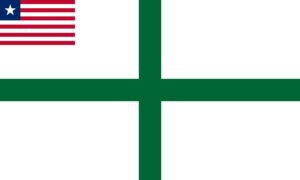
Flag
The flag of Sinoe represents purity, forestry, and agriculture of the area.
Technical Description
The flag is a green cross on a white background with the flag of Liberia in the top-left corner.
Design Elements and Symbolism
White Background – Stands for purity.
Green Cross – Depicts the tropical forests, agriculture and farming of the local people.
Liberian Flag Canton – National unity.
Climate
Sinoe has a tropical climate. Due to the large area of forest cover of Sinoe, the county experiences a frequent and heavy rainfall during the year.
Geography
Sinoe county has lower tropical forests which has mid size hills composed of various valleys and water courses. These forests receive a very high rainfall ranging from 3,000 mm (120 in) to 4,100 mm (160 in) per year in two distinct seasons. It has evergreen forests. While in the uplands it is conducive for rice cultivation, the low-lying areas are conducive for yam, cocoa, plantains, potatoes, vegetables, rubber, coffee and sugarcane. Sinoe County has two community forests: Nitrian with an area of 958 ha (2,370 acres) and Nimopho with an area of 7,320 ha (18,100 acres). It has the Sapo National Park (180,436 ha (445,870 acres), a National protected area. Sankwehn Proposed Reserve, occupying an area of 80,348 ha (198,540 acres) is a National proposed reserve, while LTPC Reforestation Project with an area of 154.2 ha (381 acres)) is a National plantation area.
Topography
The county features a mix of elevations, including gentle hills in the southeastern areas and higher ridges and steep hills in the north. (Credit IDH).
Geology
The geology of Sinoe is characterized by a geology dominated by Archean to Palaeoproterozoic gneisses, part of the West African Craton, with greenstone belts that are associated with mineral deposits like gold and iron ore. The county also has a lengthy coastline with white sandy beaches and lush greenery, including the Sapo National Park, which is home to a significant expanse of rainforest. The county can also boast of Diamond, Fishery, Oil Palm, Rubber, and Coconut aside from Gold and Iron ore. The soil formation is laterite. (Credit sciencedirect.com)
Vegetation
Sinoe’s natural vegetation is composed of the largest forest area cover among all the 15 counties. The region has evergreen forests which features lower tropical forests with diverse vegetation types. The protected and proposed reserves support conservation of forest ecosystems and biodiversity, including national parks and reforestation projects.
Religion and Culture
There are three major faiths practiced in Sinoe: Christianity, Islam and African traditional practices also have major impact on religious practices in the County. Christianity is the dominant religion, followed by Islam. The dominant local Christian denominations include the Catholic Church, Lutheran Church and the Pentecostal Related Churches.
The culture, language, and traditional practices by the ethnic groups such as the Bassa, Gio, Grebo, Krahn, Kru, and the Sapo group has shaped the way the people have lived in the Sinoe county.
Ethnic Composition
Six of the ethnic groups that are represented in higher numbers are the Bassa, Gio, Grebo, Krahn, Kru, and the Sapo group.
Credit Sources:
Republic of Liberia – Ministry of Internal Affairs
Liberian Government Gazette (1964 Establishment Act)
National Archives of Liberia
Sinoe County Administration
Official County Publications
County Development Agenda (CDA)
2022 Housing and Population Census: Liberia Institute of Statistics and Geo-Information Services (LISGIS)
National Elections Commission (NEC), Republic of Liberia
Senate.gov.lr
Sinoe District 1
Sinoe Electoral District 1 has a registered voter population of 20,783 made up of 10,799 males and 9,984 females as of July 2023.
Sinoe District 2
Sinoe Electoral District 2 has a registered voter population of 18,439 made up of 10,981 males and 7,458 females as of July 2023.
Sinoe District 3
Sinoe Electoral District 3 has a registered voter population of 16,357 made up of 8,937 males and 7,420 females as of July 2023.
Sinoe Districts (Administrative)
Sinoe County has 20 Administrative Districts according to the 2022 census by the LISGIS (Bar-Nakay, Bodae, Bokon, Butaw, Greenville, Jaedae, Jaedepo, Jlah, Juarzon, Kpayan, Krah, Kulu, Plahn, Pynes Town, Sarboh,