 |
|
|
| Superintendent | Senator (senior) | Senator (junior) |
| J. Lavalah Massaquoi | Joseph Kpator Jallah | Momo T. Cyrus |
| County Profile Overview: Lofa | |||||
|---|---|---|---|---|---|
| Year Established | Capital | Population (2022) | Area | Electoral Districts | Population Density |
| 1964 | Voinjama | 367,376 | 9,978km² | 5 | 36.82 persons/km² |
Created in 1964, Lofa County, located in Liberia, is a first-level administrative division with its capital is is Voinjama.
Background and Introduction
Spanning 9,978 square kilometers (km²), Lofa is one of Liberia’s 15 counties Lying in the north-western corner of Liberia. Lofa is bounded on the east and north by Guinea, west by Sierra Leone and on the south by Gbarpolu and Bong counties. Lofa County is now the second largest County in Liberia. It is bounded on the east and the north by Guinea, on the west by Sierra Leone and on the south by Gbarpolu and Bong Counties.
There are 5 Electoral Districts (ED) 1, 2, 3, 4, and 5; and 11 Administrative Districts (Foya, Kolahun, Salayea, Vahun, Voinjama, Zorzor, Quardu Boundi, Lukameh, Wahasa, Waum and Tengia), comprising 7 Chiefdom and 30 Clans. County leadership is headed by a superintendent, while districts, townships, and boroughs are governed by representatives and senators, commissioners, and governors respectively. See the Table below.
| Administrative Structure Overview: Lofa | ||
|---|---|---|
| Category | Count | Details |
| Electoral Districts | 5 | ED 1, ED 2, ED 3, ED 4, ED 5 |
| Administrative Districts | 11 |
Foya, Kolahun, Salayea, Vahun, Voinjama, Zorzor, Quardu Boundi, Lukameh, Wahasa, Waum, Tengia |
| Chiefdoms | 7 | County total |
| Clans | 30 | County total |
According to the 2022 census by the Liberia Institute of Statistics and Geo-Information Services (LISGIS), the population stands at 367,376 made up of 183,100 males and 184,276 females representing 49.8% and 50.2.% respectively. See the Table below.
| Administrative Districts Population Overview: Lofa (County Total: 367,376) | ||||||
|---|---|---|---|---|---|---|
| Admin District | Male | Male % | Female | Female % | Total | % of County Population |
| Foya | 23,247 | 49.6% | 23,647 | 50.4% | 46,894 | 12.8% |
| Kolahun | 14,518 | 49.0% | 15,085 | 51.0% | 29,603 | 8.1% |
| Salayea | 14,303 | 49.4% | 14,657 | 50.6% | 28,960 | 7.9% |
| Vahun | 14,740 | 52.8% | 13,181 | 47.2% | 27,921 | 7.6% |
| Voinjama | 30,763 | 50.2% | 30,545 | 49.8% | 61,308 | 16.7% |
| Zorzor | 24,965 | 49.3% | 25,716 | 50.7% | 50,681 | 13.8% |
| Quardu Boundi | 11,275 | 49.4% | 11,569 | 50.6% | 22,844 | 6.2% |
| Lukameh | 12,363 | 50.6% | 12,054 | 49.4% | 24,417 | 6.6% |
| Wahasa | 17,368 | 49.9% | 17,428 | 50.1% | 34,796 | 9.5% |
| Waum | 11,342 | 48.8% | 11,919 | 51.2% | 23,261 | 6.3% |
| Tengia | 8,216 | 49.2% | 8,475 | 50.8% | 16,691 | 4.5% |
| Total | 183,100 | 49.8% | 184,276 | 50.2% | 367,376 | 100.0% |
According to the 2022 census by the Liberia Institute of Statistics and Geo-Information Services (LISGIS), the population stands at 367,376 made up of 183,100 males and 184,276 females representing 49.8% and 50.2.% respectively and 7% of the national population figure of 5,250,187. See the Table below.
| County Population Overview: Lofa | ||||||
|---|---|---|---|---|---|---|
| Population (2022) | Male | Percent | Female | Percent | National Percentage | National Total |
| 367,376 | 183,100 | 49.8% | 184,276 | 50.2% | 7% | 5,250,187 |
Six major dialects are spoken in the County. These include Lorma (spoken by the majority 51%), Gbandi (spoken by 26%), Kissi (Spoken by 12%), Kpelle (Spoken by 6%), Mandingo (Spoken by 3%), Mende and Others (spoken by 2%).
History
Lofa County has six political sub-divisions, namely: Salayea, Zorzor, Voinjama, Kolahun, Foya and Vahun; one Township, Zogolomai, and one additional pending District, Quadru Gboni. The capital of Lofa is Voinjama. At least six of Liberia’s tribes (Lorma, Kissi, Gbondi, Mende, Mandingo and Kpelle) are resident in Lofa County.
Traditional culture remains strong in Lofa with the Poro and Sande societies still playing a critical role in the education and initiation of boys and girls. The two largest tribes are the Lorma and Gbandi, which are largely Christian and Muslim respectively. The two coexisted peacefully prior the conflict, but current issues of land ownership, traditional practices and power sharing have led relations to deteriorate. Before the war, Lofa was considered the “breadbasket” of Liberia as a result of its high level of food production, especially of rice, the national staple food.
Lofa became a county by an act of the Legislature in 1964. Before this time the area was known as the Western Province, comprising of four Districts: Kolahun, Voinjama, Zorzor, and Swan Bopolu. Lofa County was for decades the largest county in Liberia, with eleven administrative districts and a population made up of at least eight
of the sixteen major tribal groups in Liberia. Five administrative districts have since been redesignated to form what is now called Gbarpolu County. Lofa County currently consists of six administrative districts (Salayea, Zorzor, Voinjama, Kolohun, Foya, and Vahun) and Zogolimai Township. A chiefdom in Voinjama district is currently being transformed by an act of legislation into Lofa County’s seventh district, to be called Quardu Gbondi. The County’s population is now made up of at least six distinct ethnic groups, including the Kpelleh, Lorma, Mandingo, Kissi, Gbandi and Mende.
Initially, before the declaration of Gbarpolu as a County, the total land area of Lofa County was 7600 square miles, or 19,683.90 square kilometres. From that time until now, the land area of Lofa County is not known.
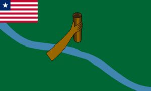
Flag
The flag of Lofa represents unity, forest and agriculture and the historical river.
Technical Description
The flag incorporates three colours: green, light blue and brown. In the middle of the flag there is a hand holding a stick, a blue river running diagonally across the vast green background with the Liberian flag in the canton and the county emblem displayed on the field.
Design Elements and Symbolism
Green – Represents the vast forest of Lofa County.
Blue River – Represents the river commonly known as the Lofa River, after which the county was named.
Brown Hand – hand holding a stick, symbolizes unity.
Liberian Flag Canton – Unity with the Republic.
Climate
The climate in Lofa County is tropical, hot and humid. Based on the prevailing precipitation, two seasons are differentiated. The rainy season lasts from mid April to mid-October. The dry season begins in November and ends in April. The temperature normally ranges annually from 24C to 30C (75F to 85F). Data on winds in Lofa County is incomplete, but wind generally blows from the Northeast during the dry season and from the Southwest during the rainy season. The total wind mileage is greatest in the rainy season from July to September and lowest in the dry season during December and January.
Lofa County has an average rainfall of around 115 inches (2,900mm). Three principal types of rainfall can be distinguished. First, heavy downpours occur at the beginning and at the end of the rainy season. Second, longer periods of precipitation with less turbulence occur, covering larger areas. The intensity of this kind of rainfall is increased through the drop of temperature during the afternoon and the night hours.
Third, “Relief Rains” are produced by the friction between the topography and air masses which reach the county from the sea. Relief rains occur at mountain ranges and other relief features.
Topography
The plateaus and mountain ranges lie behind rolling hills. Table lands reach heights of up to 1000 ft-2000 ft (609.6 m) and mountain ranges are found up to 2000 ft. (600 m). Important ranges are the Wologisie, Wutivi and Wanigisi. The greatest width of this zone is 80 miles (130 km) between the Lofa and St. Paul Rivers. The belt of rolling hills parallel to the east zone has elevation in the order of 300ft (90 m). There are numerous hills, valleys and water courses in this zone.
Geology
All three kinds of soil produced by different conditions of climate and vegetation in Liberia are found in Lofa: clay loam, sandy clay loam, and loam.
Vegetation
Vegetation in Lofa is composed of tropical rain forest including high forest, broken forest and low bush. The type of forest most common to Lofa County is known as Moist Semi Deciduous Forest. Some of the most common trees are the nesogordonia papaverifera, the limba (or terminalia superb), and the obechi (or triplochiton scleroxylon).
Religion and Culture
While accurate statistics will only emerge from the 2008 Census, it is known that Lofa County is predominantly Christian with a sizeable Muslim minority, along with a few practitioners of other religions. The presence of these groups is felt in every part of the County. The people of Lofa have strong traditional cultural practices that provided some measure of social cohesion in the era before the civil crisis. During the war, some of these cultural practices tended to wane, but as normality is restored, the traditions are starting to come back. The Poro is a traditional school where the young men learn basic survival skills and civic responsibilities. The male graduation from the Poro Society is a cultural festival only compared to the carnival of the Caribbean Islands and Brazil. The citizens of Lofa often use their traditional and cultural traditions as a comparative advantage in agriculture, working in traditional kuu (cooperatives), as well as in education and family life.
Credit Sources:
Republic of Liberia – Ministry of Internal Affairs
Liberian Government Gazette (1964 Establishment Act)
National Archives of Liberia
Lofa County Administration
Official County Publications
County Development Agenda (CDA)
2022 Housing and Population Census: Liberia Institute of Statistics and Geo-Information Services (LISGIS)
National Elections Commission (NEC), Republic of Liberia
Senate.gov.lr
Lofa District 1
Lofa Electoral District 1 has a registered voter population of 39,844 made up of 18,975 males and 20,869 females as of July 2023.
Lofa District 2
Lofa Electoral District 2 has a registered voter population of 26,710 made up of 13,662 males and 13,048 females as of July 2023.
Lofa District 3
Lofa Electoral District 3 has a registered voter population of 29,606 made up of 13,699 males and 15,907 females as of July 2023.
Lofa District 4
Lofa Electoral District 4 has a registered voter population of 43,061 made up of 20,579 males and 22,482 females as of July 2023.
Lofa District 5
Lofa Electoral District 5 has a registered voter population of 37,908 made up of 18,386 males and 19,522 females as of July 2023.
Lofa Districts (Administrative)
Lofa 11 Administrative (Foya, Kolahun, Salayea, Vahun, Voinjama, Zorzor, Quardu Boundi, Lukameh, Wahasa, Waum and Tengia), with a population of 367,376.