 |
 |
 |
| Superintendent | Senator (senior) | Senator (junior) |
| Hawa Loleyah Norris | Prince K. Moye | Johnny K. Kpehe |
All Districts Leadership in Bong
| County Profile Overview: Bong | |||||
|---|---|---|---|---|---|
| Year Established | Capital | Population (2022) | Area | Electoral Districts | Population Density |
| 1964 | Gbarnga | 467,561 | 1,942 km² | 7 | 53.32 persons/km² |
Created in 1964, Bong County, located in Liberia, is a first-level administrative division with its capital in Gbarnga.
Background and Introduction
Spanning 8,769 square kilometers (km²), Bong is one of Liberia’s 15 counties situated in the Northeastern region of Liberia and bordered by Lofa County on Northwest, Gbarpolu County on the West, Margibi County on the Southwest, Grand Bassa County on the South and South-East, and Nimba County on the East and the North-East. On the North, Bong County is bordered by the Republic of Guinea.
There are 7 Electoral Districts (ED) 1, 2, 3, 4, 5, 6, and 7; and 12 Administrative Districts (Fuamah, Jorquelleh, Yeallequelleh, Panta, Salala, Sanoyeah, Suakoko, Zota, Kokoyah, Tukpahblee, Boinsen, and Kpaii), comprising 14 Chiefdoms and 42 Clans. County leadership is headed by a superintendent, while districts, townships, and boroughs are governed by representatives and senators, commissioners, and governors respectively. See the Table below:
| Administrative Structure Overview: Bong | ||
|---|---|---|
| Category | Count | Details |
| Electoral Districts | 7 | ED 1, ED 2, ED 3, ED 4, ED 5, ED 6, ED 7 |
| Administrative Districts | 12 | Fuamah, Jorquelleh, Yeallequelleh, Panta, Salala, Sanoyeah, Suakoko, Zota, Kokoyah, Tukpahblee, Boinsen, Kpaii |
| Chiefdoms | 14 | County total |
| Clans | 42 | County total |
According to the 2022 census by the Liberia Institute of Statistics and Geo-Information Services (LISGIS), the population of the administrative districts stands at 467,561 (235,208 males and 232,353 females) representing 50.3% and 49.7% respectively. See the Table below:
| Administrative Districts Population Overview: Bong (County Total: 467,561) | ||||||
|---|---|---|---|---|---|---|
| Admin District | Male | Male % | Female | Female % | Total | % of County Population |
| Fuamah | 18,197 | 51.9% | 16,858 | 48.1% | 35,055 | 7.5% |
| Jorquelleh | 71,841 | 49.5% | 73,394 | 50.5% | 145,235 | 31.1% |
| Yeallequelleh | 21,928 | 50.2% | 21,767 | 49.8% | 43,695 | 9.3% |
| Panta | 10,001 | 50.4% | 9,852 | 49.6% | 19,853 | 4.2% |
| Salala | 26,835 | 50.7% | 26,093 | 49.3% | 52,928 | 11.3% |
| Sanoyeah | 20,273 | 51.4% | 19,194 | 48.6% | 39,467 | 8.4% |
| Suakoko | 22,516 | 50.1% | 22,414 | 49.9% | 44,930 | 9.6% |
| Zota | 11,201 | 50.4% | 11,005 | 49.6% | 22,206 | 4.7% |
| Kokoyah | 1,980 | 49.4% | 2,032 | 50.6% | 4,012 | 0.9% |
| Tukpahblee | 6,441 | 49.1% | 6,679 | 50.9% | 13,120 | 2.8% |
| Boinsen | 8,818 | 51.1% | 8,436 | 48.9% | 17,254 | 3.7% |
| Kpaai | 15,177 | 50.9% | 14,629 | 49.1% | 29,806 | 6.4% |
| Total | 235,208 | 50.3% | 232,353 | 49.7% | 467,561 | 100.0% |
According to the 2022 census by the Liberia Institute of Statistics and Geo-Information Services (LISGIS), the population stands at 467,561 made up of 235,208 males and 232,353 females representing 50.3% and 49.7% respectively and 8.91% of the national population figure of 5,250,187. See the Table below:
| County Population Overview: Bong | ||||||
|---|---|---|---|---|---|---|
| Population (2022) | Male | Percent | Female | Percent | National Percentage | National Total |
| 467,561 | 235,208 | 50.3% | 232,353 | 49.7% | 8.91% | 5,250,187 |
Ethnic groups found in Bong County include all of Liberia’s 16 tribes. The Kpelle people represent the largest tribal block in the County, and members of many tribes speak the Kpelle language as a result. All of the tribes have over the years been interlinked mostly through marriage.
History
Until 1964, present day Bong County was a part of Liberia known as the Central Province. Hon. Samuel B. Cooper was the last commissioner of Central Province, and the first Superintendent of Bong County was the late Hon. James Y. Gbarbea, who was instrumental in the construction of the Administrative Building in Gbarnga.
Over the years, many investments and development initiatives of national importance have been undertaken in Bong County, including:
Bong Mining Company (BMC)
Bong County Agriculture Development Project (BCADP)
Central Agriculture Research Institute (CARI)
Phebe Hospital and School of Nursing
Rubber Corporation of Liberia (RCI)
Liberia Telecommunication Corporation (LTC)
Liberia Electricity Corporation (LEC)
Cuttington University College (CUC)
The civil conflict was particularly cruel to Bong County, parts of which were contested by multiple militias over fourteen years, resulting in massive losses of life and egregious human rights abuses, especially perpetrated against women and girls. Bong County served for a time as the capital of would-be president Charles Taylor’s “Greater Liberia”, and the area provided perhaps a majority of the children and young women that were forced to join the various fighting forces.
Most of the County’s Bong County Development Agenda” 1 public infrastructure and private property was looted or destroyed. While the situation has improved since the election of the current Government and the arrival of international peacekeepers, multilateral agencies and NGOs, there is still a dangerously high unemployment rate and a need for urgent improvements in health, education, and all sectors of the economy.
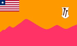
Flag
The flag of Bong County represents the mountainous terrain, mining and agricultural wealth of the county.
Technical Description
The flag consists of an orange field with a stylized purple mountain range across the lower portion with hammer on a white background. A small Liberian national flag appears in the upper hoist corner. On the fly side appears a white shield bearing three iron nails.
Design Elements and Symbolism
Orange Field – Represents fertile farmland.
Purple Mountains – Represent Bong’s highland terrain.
Liberian Flag Canton – National unity and governance.
Hammer – Represents the traditional importance of mining to the local economy.
Climate
The climate of Bong County is tropical, hot and humid. The temperature generally ranges from 65F to 85F. Based on the prevailing precipitation, two seasons are differentiated: rainy and dry. The rainy season lasts from mid-April to mid-October. The dry season begins in November and ends in April. However, with the planet experiencing climate change, a slight fluctuation in the timing of the seasons has been noticed.
Generally the wind blows from the Northeast during the dry season and from the Southwest during the rainy season. Wind mileage is normally greatest in the rainy season, sometimes bringing violent storms capable of destroying houses and crops. Bong County has a conventional type of rainfall of around 70 to 80 inches. Toward the interior, the rainfall decreases because the air loses moisture except for high areas where the air forces rise causing some relief rain.
Topography
The County is said to be well watered by six principal rivers and a number of small streams. The St. John River runs through Bong County and rises in Guinea where it is known as Mano River, north-west of the Nimba Mountains. The Mano River receives much water from Naye River, the Zoi and Yja Creeks.
Geology
The soils of Bong County are mostly latosols, which occurs on undulating and rolling land and occupies about 18% of the total land area in Liberia. This soil is heavily eached and silica nutrients and humus are readily washed out.
Vegetation
Bong County is part of the high forest belt, which can be divided into an evergreen rain forest zone and the moist semi-deciduous forest zone. The evergreen forest receives an annual rainfall of 80 inches and consists of species that do not have a marked period of leaf fall. The tallest trees reach 200 feet.
The semi-deciduous forest is a transition to the deciduous forest type found in the Ivory Coast. The long dry season (4.5 – 5.5 months) forces many species to drop their leaves during part of this period to minimize evaporation. The occurrence of this vegetation in Bong County is based on soil conditions.
Credit Sources:
Republic of Liberia – Ministry of Internal Affairs
Liberian Government Gazette (1964 Establishment Act)
National Archives of Liberia
Bong County Administration
Official County Publications
County Development Agenda (CDA)
2022 Housing and Population Census: Liberia Institute of Statistics and Geo-Information Services (LISGIS)
National Elections Commission (NEC), Republic of Liberia
Senate.gov.lr
Bong District 1
Bong Electoral District 1 has a registered voter population of 37,046 made up of 18,860 males and 18,186 females as of July 2023. See the Table below District Population Overview: Bong Electoral District 1 Population (2023) Male Percent Female Percent 37,046 18,860 50.91% 18,186 49.09%
Bong District 2
Bong Electoral District 2 has a registered voter population of 30,691 made up of 15,209 males and 15,482 females as of July 2023. See the Table below. District Population Overview: Bong Electoral District 2 Population (2023) Male Percent Female Percent 30,691 15,209 49.56% 15,482 50.44%
Bong District 3
Bong Electoral District 3 has a registered voter population of 41,840 made up of 19,134 males and 22,706 females as of July 2023. See the Table below. District Population Overview: Bong Electoral District 3 Population (2023) Male Percent Female Percent 41,840 19,134 45.73% 22,706 54.27%
Bong District 4
Bong Electoral District 4 has a registered voter population of 30,029 made up of 14,501 males and 15,528 females as of July 2023. See the Table below. District Population Overview: Bong Electoral District 4 Population (2023) Male Percent Female Percent 43,501 21,347 49.07% 22,154 50.93%
Bong District 5
Bong Electoral District 5 has a registered voter population of 32,051 made up of 15,687 males and 16,364 females as of July 2023. See the Table below. District Population Overview: Bong Electoral District 5 Population (2023) Male Percent Female Percent 32,051 15,687 48.94% 16,364 51.06%
Bong District 6
Bong Electoral District 6 has a registered voter population of 30,930 made up of 14,981 males and 15,949 females as of July 2023. See the Table below. District Population Overview: Bong Electoral District 6 Population (2023) Male Percent Female Percent 30,930 14,981 48.42% 15,949 51.58%
Bong District 7
Bong Electoral District 7 has a registered voter population of 32,200 made up of 16,260 males and 15,940 females as of July 2023. See the Table below. District Population Overview: Bong Electoral District 7 Population (2023) Male Percent Female Percent 32,200 16,260 50.50% 15,940 49.50%
Bong Districts (Administrative)
Bong County has 12 Administrative Districts (Fuamah, Jorquelleh, Yeallequelleh, Panta, Salala, Sanoyeah, Suakoko, Zota, Kokoyah, Tukpahblee, Boinsen, and Kpaii), with a population of 467,561.