 |
 |
 |
| Superintendent | Senator (senior) | Senator (junior) |
| Mike T. Swengbe | Jonathan Sogbie | Francis Saidy Dopoh II. |
All Districts Leadership in River Gee
| County Profile Overview: River Gee | |||||
|---|---|---|---|---|---|
| Year Established | Capital | Population (2022) | Area | Electoral Districts | Population Density |
| 2,000 | Fish Town | 124,653 | 5,110km² | 3 | 24.39 persons/km² |
Created in 2000, River Gee County, located in Liberia, is a first-level administrative division with its capital Fish Town.
Background and Introduction
Spanning 5,110 square kilometers (km²), River Gee is situated in southeastern Liberia. It is bounded on the North by Grand Gedeh County, on the East by Ivory Coast, on the West by Sinoe County, and on the South by Maryland County.
There are 3 Electoral Districts (ED) 1, 2, and 3; and 10 Administrative Districts (Chedepo, Karforh, Nanee, Gbeapo, Nyenawliken, Potupo, Glaro, Sarbo, Tuobo and Nyenebo), comprising 23 Chiefdom and 51 Clans. County leadership is headed by a superintendent, while districts, townships, and boroughs are governed by representatives and senators, commissioners, and governors respectively. See the Table below.
| Administrative Structure Overview: River Gee | ||
|---|---|---|
| Category | Count | Details |
| Electoral Districts | 3 | ED 1, ED 2, ED 3 |
| Administrative Districts | 10 | Chedepo, Karforh, Nanee, Gbeapo, Nyenawliken, Potupo, Glaro, Sarbo, Tuobo, Nyenebo |
| Chiefdoms | 23 | County total |
| Clans | 51 | County total |
According to the 2022 census by the Liberia Institute of Statistics and Geo-Information Services (LISGIS), the population stands at 124,653 made up of 79,362 males and 71,787 females representing 52.5% and 47.5% respectively. See the Table below.
| Administrative Districts Population Overview: River Gee (County Total: 124,653) | ||||||
|---|---|---|---|---|---|---|
| Admin District | Male | Male % | Female | Female % | Total | % of County Population |
| Chedepo | 6,123 | 51.0% | 5,885 | 49.0% | 12,008 | 9.6% |
| Karforh | 2,722 | 51.8% | 2,534 | 48.2% | 5,256 | 4.2% |
| Nanee | 6,816 | 56.5% | 5,249 | 43.5% | 12,065 | 9.7% |
| Gbeapo | 10,007 | 51.0% | 9,608 | 49.0% | 19,615 | 15.7% |
| Nyenawliken | 7,606 | 53.9% | 6,496 | 46.1% | 14,102 | 11.3% |
| Potupo | 16,390 | 52.0% | 15,143 | 48.0% | 31,533 | 25.3% |
| Glaro | 2,485 | 55.6% | 1,985 | 44.4% | 4,470 | 3.6% |
| Sarbo | 3,902 | 52.1% | 3,592 | 47.9% | 7,494 | 6.0% |
| Tuobo | 5,307 | 52.0% | 4,898 | 48.0% | 10,205 | 8.2% |
| Nyenebo | 4,113 | 52.0% | 3,792 | 48.0% | 7,905 | 6.3% |
| Total | 65,471 | 52.5% | 59,182 | 47.5% | 124,653 | 100.0% |
According to the 2022 census by the Liberia Institute of Statistics and Geo-Information Services (LISGIS), the population stands at 124,653 made up of 79,362 males and 71,787 females representing 52.5% and 47.5% respectively and 2.37% of the national population figure of 5,250,187.
River Gee is the second youngest county aside Gbarpolu being the youngest. See the Table below.
| County Population Overview: River Gee | ||||||
|---|---|---|---|---|---|---|
| Population (2022) | Male | Percent | Female | Percent | National Percentage | National Total |
| 124,653 | 79,362 | 52.5% | 71,787 | 47.5% | 2.37% | 5,250,187 |
History
River Gee is one of the newest counties in Liberia. It was carved out of Grand Gedeh County, which was formerly part of the Eastern Province prior to 1964. The County was established in 2000 and has its political seat in Fish Town. Establishment of the County was predicated upon growing tensions between the Grebo and Krahn ethnic groups over the years, particularly during the 1980s and 1990s, characterized by military and phantom democratic regime of Samuel Doe, and the early war years of Charles Taylor. The quest for a separate political identity was eminent, owing to the rancor between the two groups. River Gee County is predominantly peopled by the Grebo ethnic group, with smaller numbers of Liberia’s other ethnic groups. River Gee has three large settlements: Fish Town, which is famous for its catfish water, Kanweaken, which is a commercial Town, and Webbo, noted for missionary activities.
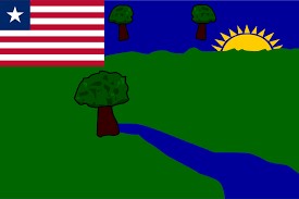
Flag
The flag of River Gee represents agriculture, forests, and rural development.
Technical Description
The flag incorporates imagery representing rivers, sun and forests, a blue and green background with the Liberian flag in the canton and the county emblem on the field.
Design Elements and Symbolism
Red and Green – Depicts the fertile land, rich resources, and the natural environment of the county.
River – Represents local waterways, the Gee (or Chee) River, from which the county derives its name. “Gee” means “Leopard” in the local Grebo vernacular, referring to the “Leopard’s River”
Sun – Being the last but one youngest county in Liberia, the rising sun represents the birth of a new county.
Trees – Represents the vast forests and environmental resources.
Liberian Flag Canton – The seal emphasizes River Gee’s recognition as one of Liberia’s newer counties with strong rural foundations.
Climate
River Gee’s climatic condition is typical of the upper southern part of Liberia, characterized by warm temperatures and extremely high humidity. Seasonal changes of temperature and humidity are minor, although there are variations between day and night. There are basically two seasons, the rainy and the dry. The rainy season runs from April to November, while the dry runs from November to April. Average annual rainfall of River Gee is 107 inches, and the average temperature is 77.5ºF.
Geography
River Gee is situated in southeastern Liberia. It is bounded on the North by Grand Gedeh County, on the East by Ivory Coast, on the West by Sinoe County, and on the South by Maryland County. River Gee has a total land area of 5,627 square kilometers.
Topography
The topography of River Gee is typical of the highlands of Liberia. It is generally hilly. Gradients are steep and irregular. Important highlands are the Tienpo Mountain and the Killepo Range. River valleys are v-shaped and narrow in their upper reaches. Drainage systems include the Cavalla, Dugbe, Gee, Nun and Gbeh Rivers, as well as numerous creeks and tributaries, resulting in a dendritic (tree-like) drainage pattern. Waterfalls, rapids and crags are typical characteristics of the rivers and streams.
Geology
Thegeology of River Gee has similar features to most other parts of Liberia. The formation of rocks forms part of the West African Croton, noted for the absence of tectonic activities over the last 250 million years.
Vegetation
Vegetation of River Gee County is typical of the tropical rain forest, which is characterized by evergreen and semi deciduous forest. Logging and farming activities over the years have contributed to about 2.6% loss of the forest in the County. Nonetheless, the County still boasts of ample forest and timber for harvest.
Religion and Culture
There are three major faith practiced in River Gee is Christianity, Islam and African traditional practices also have major impact on religious practices in the County. Christianity is the dominant religion, followed by Islam. The dominant local Christian denominations include the Catholic Church, the Pentecostal Related Churches and the Evangelicals.
The culture and way of life in River Gee is largely shaped by the traditional, cultural and religious practices of the main ethnic groups of the county being the Gio, Mano, Grebo and Krah groups.
Ethnic Composition
The dialects spoken in the County include Gio, Mano, Grebo and Krahn vernaculars with the most often spoken in the County being Grebo, the largest ethnic group, accounting for some 92% of the total population followed by the Krahn group.
Credit Sources:
Republic of Liberia – Ministry of Internal Affairs
Liberian Government Gazette (1964 Establishment Act)
National Archives of Liberia
River Gee County Administration
Official County Publications
County Development Agenda (CDA)
2022 Housing and Population Census: Liberia Institute of Statistics and Geo-Information Services (LISGIS)
National Elections Commission (NEC), Republic of Liberia
Senate.gov.lr
River Gee District 1
River Gee Electoral District 1 has a registered voter population of 12,008 made up of 6,422 males and 5,586 females as of July 2023. See the Table below. District Population Overview: River Gee Electoral District 1 Population (2023) Male Percent Female Percent 12,008 6,422 53.48% 5,586 46.52%
River Gee District 2
River Gee Electoral District 2 has a registered voter population of 13,756 made up of 7,187 males and 6,569 females as of July 2023. See the Table below. District Population Overview: River Gee Electoral District 2 Population (2023) Male Percent Female Percent 13,756 7,187 52.25% 6,569 47.75%
River Gee District 3
River Gee Electoral District 3 has a registered voter population of 12,043 made up of 6,142 males and 5,901 females as of July 2023. See the Table below. District Population Overview: River Gee Electoral District 3 Population (2023) Male Percent Female Percent 12,043 6,142 50.99% 5,901 49.01%
River Gee Districts (Administrative)
River Gee County has 10 Administrative Districts (Chedepo, Karforh, Nanee, Gbeapo, Nyenawliken, Potupo, Glaro, Sarbo, Tuobo and Nyenebo), with a population of 124,653.